
In December 2021, the American Battlefield Trust purchased 245-acres of the Williamsburg Battlefield known today as the Egger Tract and as the Custis Farm during the Civil War. This acreage encompasses the entire afternoon phase of the May 5, 1862 Battle of Williamsburg. The successful acquisition was a decade in the making and required coordination and cooperation between many parties as well as the largest single grant in the American Battlefield Protection Program’s history, suggesting just how important preservation of this tract was viewed.
““People in Williamsburg have been caring about this property for so long. I will tell you that if any one of our parts had failed the house of cards would have come down. This is a big win.””
Image from Google Maps
location
Located in York County, VA, the Egger Tract is bounded on the west by Interstate-64, on the north by the Colonial National Historical Parkway, on the east by property of the U.S. Navy (Cheatham Annex), and on the south by additional battlefield property owned by the American Battlefield Trust and known as the Busch Tract. Bisecting the property from southwest to northeast is the abandoned roadbed of the old Queens Creek Road (dotted in yellow on the map above). The entirely forested land is generally level and cut with several ravines and streams that feed into Jones Pond to the east or Queens Creek to the north.
Historical Significance
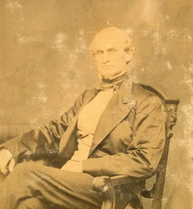
James W. Custis, ca. pre-Civil War (from The American Civil War Museum’s online media collection at www.acwm.pastperfectonline.com)
In the decade before the Civil War, this land tract in York County was known as the Custis Farm. Land records indicate that James W. Custis acquired the property about 1853 and operated it as a slave plantation. He was not the first to do so. As early as 1690, the property was farmed and then passed through several owners, including the Burwells of Carter’s Grove Plantation. James W. Custis was from Accomack County on Virginia’s Eastern Shore. He served in both houses of the Virginia legislature in the 1840s and again in the Virginia House of Delegates during the war. He was a widower with five daughters when he married the widow Clara H. Southall in Williamsburg in 1858. Custis did not live on his York County farm and instead resided in Williamsburg in his new wife’s home, which is known today as the William Finnie House and owned by The Colonial Williamsburg Foundation. An overseer lived in the farmhouse on the Custis Farm and oversaw the farm’s operations and enslaved people who worked the plantation and resided in separate quarters.
Battle of williamsburg
In 1861, the Confederate Army constructed a line of defensive works across the Peninsula at Williamsburg. Fourteen redoubts extended from Tutter’s Mill Pond northeast to Queens Creek. Fort Magruder (Redoubt 6) was the largest of the redoubts and located at the center of the defensive line where the Queens Creek Road intersected the single road into Williamsburg. From that point northeast, the entire left flank of the line ran along Queens Creek Road with Redoubts 8, 9, 10, 11, and 14 built on or near the Custis Farm property. Redoubt 11 still survives on the property in excellent condition where the old Queen’s Creek Road meets the Colonial Parkway.
When the Confederate Army was withdrawing up the Peninsula from Yorktown on May 4, General Joseph Johnston had no intention of occupying the Williamsburg defenses. An unexpectedly energetic pursuit by Union cavalry, though, precipitated the need for General James Longstreet’s division to turn around and fight a rear-guard action at Williamsburg. For reasons unknown, Redoubts 11 and 14 went unoccupied, leaving the left flank of the Confederate line wide open to attack. On the morning of May 5, at least 16 runaway slaves (possibly from the Custis Farm) informed Union commanders of the unoccupied redoubts. During the early afternoon, Union General Winfield Scott Hancock was sent with five regiments and ten guns to occupy the vacant redoubts, which he easily accomplished. He then moved artillery south on Queens Creek Road and placed several guns on the Custis Farm and inside the fenced yard of the farmhouse in order to shell Fort Magruder and Redoubts 9 and 10, which were occupied by South Carolina troops. Union skirmishers were sent out in front of the guns while the regiments were positioned around the farm buildings and Redoubt 11.

Map Courtesy of the American Battlefield Trust (www.battlefield.org)
Union troops remained in this position for several hours. Late in the afternoon, though, Hancock’s artillery fire finally drew interest and Confederate commanders realized their blunder. Four infantry regiments with no artillery support under General Jubal Early were sent to attack Hancock’s forces. Marching towards the sound of the guns through dense woods and ravines, the regiments became separated and only two reached the Custis Farm. The 24th VA emerged into the open farmland first just north of the farm buildings and rushed forward through the farmyard, knocking down the fencing, to try to capture the Union guns. The 5th NC emerged next but several hundred yards south of the 24th VA. While under fire, it crossed the open distance to support the 24th VA. By now, Hancock had pulled back his artillery and infantry and aligned them on both sides of Redoubt 11 to face the on-coming Confederate attack. The Confederates rashly pushed on across the open fields of green wheat shoots to a fence line 40 yards in front of Redoubt 11 where they halted and began to exchange fire with the Union forces. Union superiority in numbers and ordnance quickly took a terrible toll. The ill-advised, piecemeal Confederate attack was repulsed with horrible losses. From his part in the battle, General Hancock won his sobriquet, “Hancock the Superb,” which was taken from a telegraph relaying the results of the battle in which General George McClellan indicated “Hancock was Superb.”

Partial Image of “Hancock’s Brigade Repulsing the Enemy. Battle of Williamsburg” by Alfred R. Waud and Published in Harper’s Weekly May 24, 1862 (Image Courtesy of Library of Congress with notations added by WBA)
Aftermath
After the Confederate retreat, the Custis Farm was left in the hands of Union forces, and Hancock was reinforced. The Confederate wounded and prisoners were herded into Redoubt 11 during the night, and the following day, the Custis Farm buildings became a field hospital. Two days after the battle Casper Dean of the 6th Vermont Regiment wrote, “When we took Hancock’s position, the ground near to us was strewn with dead and wounded rebels. The sight was a horrible one. Our men were busy all day in burying the dead and taking care of the wounded rebels. 175 wounded rebels were taken to two large barns, and our surgeons dressed their wounded. A great many limbs were amputated.” The bodies of the soldiers killed in action were buried on the field as well as those of soldiers who subsequently died of wounds at the farm. There is a strong possibility the Egger Tract still contains the graves of these Confederates soldiers. An attempt was made to locate and remove the Union dead from the Williamsburg Battlefield in 1867, but there is no record of any attempt to remove the Confederate dead.

Custis Farm Buildings Used as Hospitals Following the Battle (Original Image Source Unknown)
Preservation effort
Early 20th-century maps show no structures surviving on the now reforested land, and other than some logging and hunting, the land rested quietly in pristine condition. Then, in the early 21st-century, the Egger Tract experienced a new battle between developers and preservationists, who had to overcome the whopping $9.2 million value of the land to claim victory. A $4.6 million National Park Service American Battlefield Protection Program grant was key to the successful purchase of the property. Additional grants were provided by the Virginia Battlefield Preservation Fund, the Virginia Land Conservation Foundation, and the U.S. Department of Defense’s Readiness and Environmental Protection Integration Program. The American Battlefield Trust also received donations from its members and the public.

Outside Redoubt 11 on the Egger Tract in Fall 2022 (Image Courtesy of American Battlefield Trust)
future benefits & plans
The Egger Tract is now protected by a perpetual historic preservation and open-space easement held by Virginia’s Department of Historic Resources, whose Director Julie V. Langan stated, “This easement preserves and protects a vital array of historic and archaeological resources important to all Virginians’ history.” In the future, the Department of Historic Resources, American Battlefield Trust, and Williamsburg Battlefield Association would like to see public archaeology performed on the site, improved public access, amenities constructed for programming and educational purposes, restoration of the landscape to its 1862 appearance, and addition of walking trails, interpretive signage, and exhibits. There is even the hope of a rail-to-trail connection between the Egger, Busch, and Smith Tracts.